

On August 28th, GeoSquare held another webinar session featuring how the GeoSquare grid system accelerates geospatial analysis to a new level. The Google Meet room buzzed with interactive polls, live Q&A, and participants from diverse industries eager to learn how GeoSquare simplifies geospatial data.
Head of Geospatial Data, Azza Sawungrana, explains how traditional maps are sometimes too hard to interpret, especially for non-specialists. He opened the session by comparing two maps and had the participants estimate the areas of land use. Most participants quickly realized that interpreting traditional polygon-based maps is not as straightforward as it seems.
“It’s not easy. It’s not straightforward for your brain to interpret these maps,” Azza explained, showing how complex shapes increase cognitive load. By contrast, GeoSquare’s approach uses uniform squares that allow anyone — even non-experts like sales or business development teams — to directly see and calculate land use without guesswork.
He linked this to Cognitive Load Theory, noting that by simplifying shapes into squares, users can focus on the content of the map rather than being distracted by irregular geometry.
Why Squares Work Better
GeoSquare’s system replaces traditional polygons with grids ranging from 50 kilometers down to 5 meters, and possibly even 1 meter in the future. This square-based structure is both intuitive and practical: one square equals one fixed area, making comparisons and measurements simple.
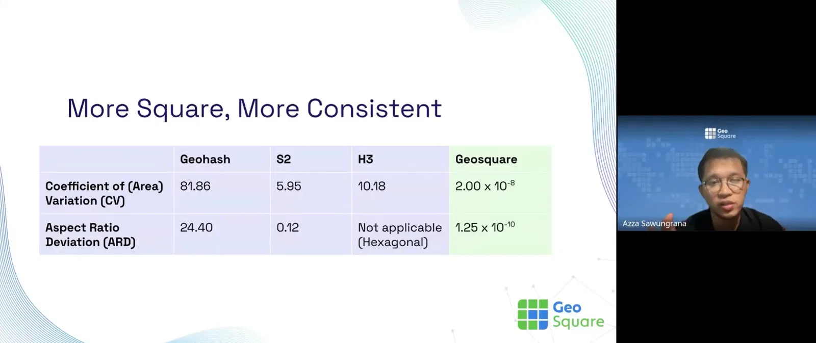
While Uber’s H3 uses hexagons, Azza noted that hexagons are harder for most people to visualize. “With squares, you just go five meters forward and five meters to the right — it’s simple. With hexagons, you’d have to think in 30 or 45-degree angles, and that’s not intuitive,” he said.
A Local-first Approach with Global Potential
Existing global systems like Geohash and Google’s S2 struggle with area inconsistencies, especially between equatorial and higher latitudes. To solve this, GeoSquare developed its own nation-based system, starting with Indonesia. The system uses a reverse Z-order for unique alphanumeric identifiers, ensuring consistent area representation while keeping the grid lightweight and scalable.
Efficiency and Cost Savings
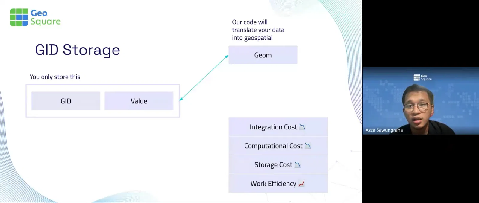
One of GeoSquare’s biggest breakthroughs is that it does not store geometry. Instead, each square is represented by a unique identifier, which can then be translated back into geometry on demand.
This approach drastically reduces integration, storage, and computation costs, making it highly efficient for cloud environments and big data workflows.
“You don’t have to do intersections or overlays anymore — it’s just like joining tables,” Azza said, emphasizing how this method accelerates machine learning and data exchange pipelines.
Applications and Open-Source Release
GeoSquare already powers use cases in credit risk, land appraisal, demographic analysis, and location scoring. Azza also highlighted its compatibility with Alpha Earth, Google’s Earth-scale model that uses pixel-like structures — showing how GeoSquare’s vector-based “pixels” can plug directly into AI workflows.
In one of the session’s most exciting announcements, GeoSquare officially open-sourced its system, with four projects already available:
JavaScript library: github.com/geosquareai/geosquare-js
Python package: github.com/geosquareai/geosquare-grid
QGIS plugin: github.com/geosquareai/geosquare_grid_qgis
DuckDB extension: github.com/geosquareai/geosquare_grid_duckdb
Future developments include a human-readable alias system (similar to What3Words) and a lightweight file system that regenerates geometry directly in GIS platforms.
Looking Ahead
The session concluded with discussions on ethics and privacy. While grids can be combined with behavioral data, Azza emphasized that the system actually protects privacy by generalizing individuals into squares, preventing direct tracking.
Participants were invited to explore the tools on GitHub, join the GeoSquare Discord community, and contribute ideas, code, or even just feedback. To those who are interested, here’s the link to join: https://discord.gg/8uBhW3JktC
GeoSquare’s vision is clear: to democratize geospatial analysis and make maps understandable not just for specialists, but for anyone who needs to make sense of space.