

When we hear the term "natural disaster," we often picture a sudden, unpredictable force of nature overwhelming humanity. But what if the disaster isn't entirely natural? The devastating floods and landslides that struck Aceh and Sumatra in late 2025 blurred the line between an act of God and a consequence of human action. By the time the waters receded, 969 people were dead, and another 264 were missing—a toll made all the more tragic because the disaster was not a surprise.
This was not a story of weather; it was a story of choices. It was a story of a changed planet, vulnerable landscapes, and fatal settlement patterns. By examining this tragedy through the lens of geospatial data and technology, we can uncover the critical lessons that were, in many ways, hidden in plain sight. These are not just observations about a single event, but urgent warnings for communities around the world.
Here are the five most impactful takeaways from a catastrophe that was tragically preventable, revealing how a combination of climate change, land use, and geology created a perfect storm of destruction.
1. We Had Days of Warning, But the Response Was Too Late

This was not a surprise attack from nature. Scientific agencies had been tracking the threat for days. Clear warnings were issued about the formation of a tropical cyclone system, Invest 95B, in the Strait of Malacca. Agencies like Indonesia's BMKG and online disaster mitigation communities like @infomitigasi were broadcasting alerts about the potential for extreme rainfall and flooding.
A timeline of the event shows a clear "Window for Anticipatory Action" between November 23rd and November 27th. During this period, scientific signals were strong, and cyclone formation warnings were explicit. This was the time to act, to prepare, to evacuate.
Instead, the actual, large-scale response was reactionary, kicking off around November 29th only after the first impacts were already being felt. This critical gap between prediction and action turned a forecastable weather event into a widespread humanitarian crisis. The sirens weren't loud alarms in the streets; they were quiet, persistent streams of scientific data that went unheeded—a delay that proved fatal for the hundreds of victims whose lives were lost.
2. A Cyclone Formed Where It "Shouldn't" Exist
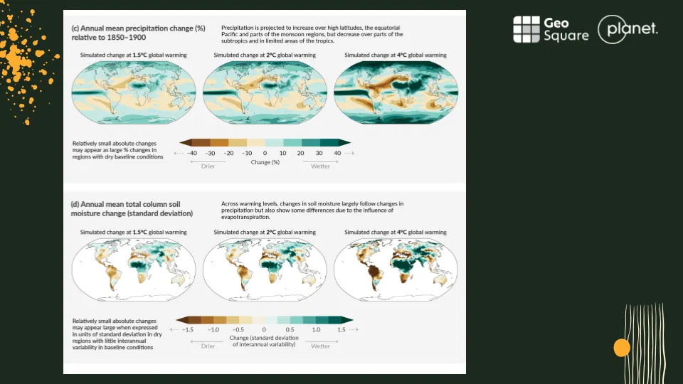
One of the most alarming facts about this disaster is a simple, counterintuitive scientific truth: tropical cyclones are not supposed to form in equatorial regions like the Strait of Malacca. The physics of storm formation generally prevents it this close to the equator.
The appearance of a powerful cyclonic system in this region is a deeply worrying anomaly. It’s a clear signal that the fundamental rules of our climate system are changing. Global climate projections, such as those from the IPCC (Intergovernmental Panel on Climate Change), illustrate how a warming world is expected to fuel an increase in precipitation across the equatorial Pacific. A warmer, wetter atmosphere provides the fuel for more extreme and unpredictable weather events, even in places previously thought to be safe from them. This single storm wasn't just a local disaster; it was a symptom of a much larger, systemic planetary illness.
3. Deforestation Stripped Away the Land's Natural "Sponge"
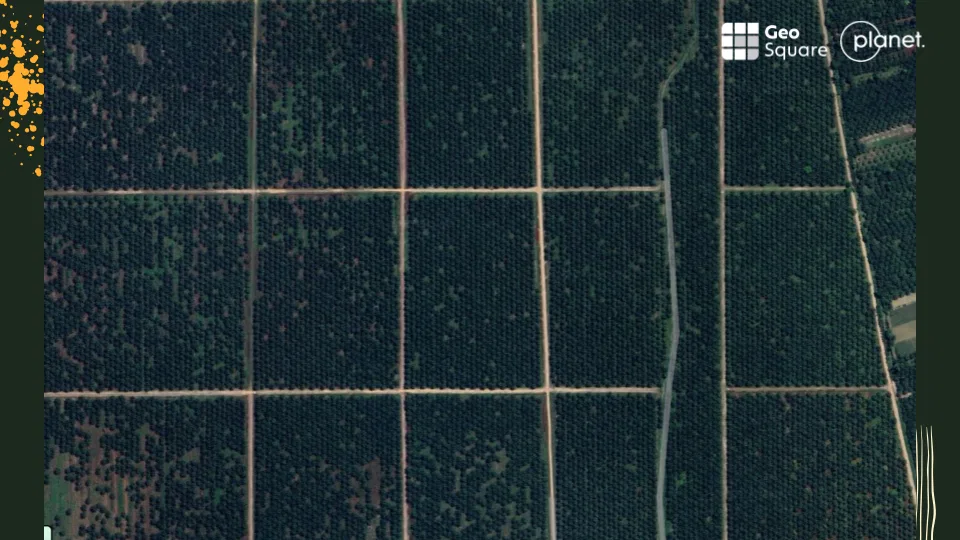
The extreme rainfall from the cyclone was only one half of the catastrophic equation. The other half was the state of the land itself. The unnatural storm met an unnatural landscape. A healthy, forested landscape acts like a natural sponge, absorbing vast quantities of rainwater and releasing it slowly. But in the upstream areas of Aceh, decades of deforestation and land conversion had destroyed this vital function.
The chain reaction was devastatingly simple. The loss of the natural "sponge effect" meant that when the heavy rains hit, the soil became saturated almost instantly. This led to catastrophic slope failures and massive landslides. The water didn't just flow; it mixed with soil, logs, and other debris to create hyper-concentrated mudflows, turning rivers into highways for sediment and destruction. The prevalence of monoculture farming, particularly vast palm oil plantations, is a significant contributor to this vulnerability, degrading soil health and further reducing its capacity to absorb water. The severity of the floods and landslides was massively amplified because the upstream landscape, altered by human hands, could no longer cope with the water it was asked to hold.
From Space, We Could Provide Quick Response Help
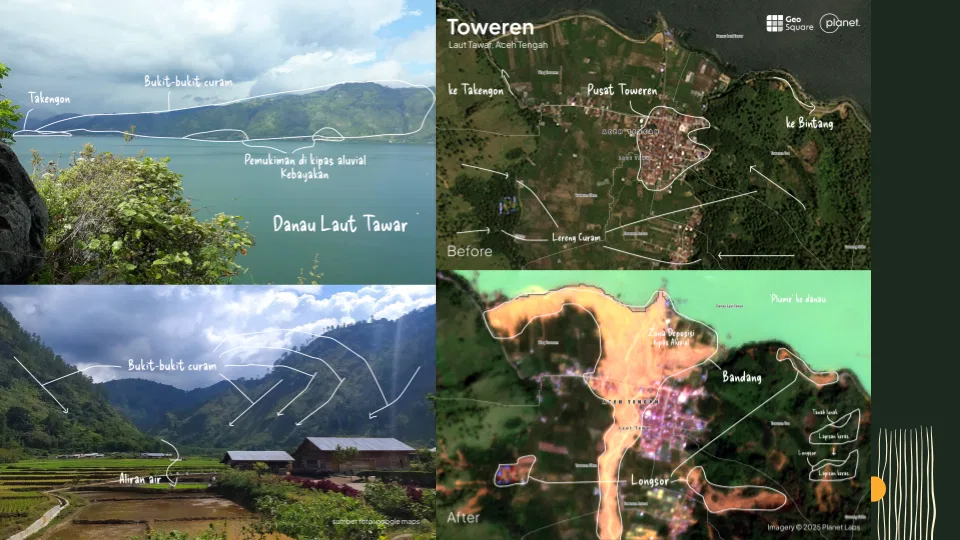
Amidst the chaos and destruction, when the landscape was unrecognizable and roads had vanished, geospatial technology provided a crucial lifeline. From hundreds of kilometers in space, analysts could cut through the confusion to provide actionable intelligence for humanitarian responders on the ground.
Different satellite sensors played unique roles. While the storm still obscured the ground from human eyes and conventional cameras, Sentinel-1's radar vision pierced the clouds, providing humanitarian responders with the first clear picture of the flood's true, devastating scale. Sentinel-2's optical sensors were used for color analysis to identify and map the scars of new landslides and sediment flows. And high-resolution imagery from PlanetScope allowed for detailed damage assessments at the village level, house by house.
This raw data was rapidly transformed into actionable intelligence by organizations like GeoSquare.ai and GeoAI Twinverse. Their analysis produced critical outputs for the response effort, including maps of Blocked Roads, safe Alternative Routes for logistics and aid convoys, and a Priority Village List that helped guide evacuation and aid delivery to the communities in greatest need. In the disaster's darkest hours, this view from space helped illuminate a path forward.
A Mandate for Leaders to Act
The 2025 Sumatra disaster was not simply a natural event. It was a tragic lesson that our greatest vulnerabilities lie at the intersection of a rapidly changing climate and the choices we make on the land. It was a failure of foresight, where scientific prediction did not translate into preventative action, and where historical patterns of land use created the conditions for a catastrophe.
This was a catastrophe by design. An anomalous cyclone fueled by a warming climate unleashed its fury on a landscape stripped of its natural defenses by deforestation. This triggered immense mudflows burying villages and the life inside. The tragedy was compounded by a response that began only after the damage was done, despite days of clear scientific warnings, leaving technology to map a disaster that knowledge could have helped prevent.
The human cost of this foresight failure is what drives disaster analysts like Azza Sawungrana of GeoSquare.ai. Speaking as part of the disaster response community, and reflecting on the news of a father who had lost his wife and all three of his children, he made an impassioned plea:
"Let's help each other and prevent disasters as early as possible before a single child loses their father, or worse, a father loses their child."
Knowing that we have the technology to predict and the knowledge to mitigate, how will we collectively ensure that the next warning siren does not fall silent?
Catch the full discussion and access our priority data below:
🔗 Watch the recording: bit.ly/RekamanWBTanggapKatdesi
📂 Access priority data lists: bit.ly/senyargeosquare