
Have you ever looked at a complex map and felt a little lost? Maps with lots of weird, wiggly shapes can be hard to read. Your brain has to work extra hard to figure out what’s going on. This is a real problem for people who need to understand information quickly.
What if maps were simpler, like a chessboard? That's the idea behind grid systems like S2 and Geohash. They chop up the world into simple, regular squares. This makes maps much easier for our brains to understand.
But there’s a catch.
The Problem with "Stretchy" Grids
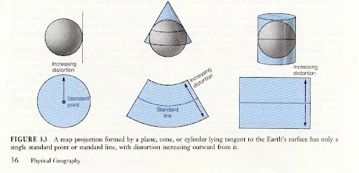
Source: faculty.kutztown.edu
The Earth is a round ball. Trying to wrap a flat grid of perfect squares around it is tricky. It’s like trying to wrap a soccer ball with a flat piece of paper without any wrinkles. It’s impossible.
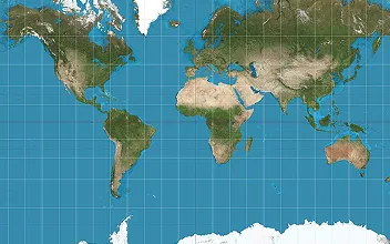
Because of this, most global grid systems have a problem. Their "grids/squares" are not all the same size. A square in one place might be much bigger than a square in another. They also get stretched out and look more like weird rectangles, especially the farther you get from the equator.
This is a big deal. If you're trying to count something, like how many trees are in each square, it's not fair if the squares are different sizes. Your results will be wrong.
GeoSquare: A Fairer Grid for One Country at a Time
This is why we created GeoSquare.
Instead of trying to map the whole world at once, GeoSquare focuses on one country at a time. We create a special grid that is perfectly made for that country.
By doing this, we can make sure every single square in the grid is:
Exactly the same size, no more stretchy squares. A 5-meter square is a 5-meter square everywhere in the country. This makes data fair and accurate.
A perfect square, un-distorted and un-warped. They stay perfectly square, which makes them easy to work with.
So, what is GeoSquare, exactly?
GeoSquare is a new way to organise map data. Some things that make it nice:
It provides a grid of consistent squares for an entire country at different zoom levels, from big 50 km squares down to tiny 5-meter ones.
Every square gets a unique, short code called a GeoSquare ID (GID). Think of it like a zip code for a piece of the Earth.
We don’t actually need to save the drawing of the square. We only need to save its GID. A special library can draw the square on a map anytime, just by reading the ID. This makes huge map datasets much, much smaller and faster to use.
Why Does This Matter?
When everyone uses the same, fair grid system, amazing things can happen. Different companies and government agencies can easily share and combine their data.
Imagine one group has data on flood risk, another has data on where people live, and another has data on where new stores are. With GeoSquare, they can all use the same GIDs to instantly layer their information together. This makes planning for cities, responding to disasters, and understanding communities much easier.
We're Making it Open Source
We believe this idea is too important to keep to ourselves. That’s why we made the GeoSquare system open source.
This means anyone will be able to use it for free. Our goal is to create a new standard for map data, making it simpler, fairer, and more powerful for everyone. Oh also, we are inviting everyone to join our community and meet every last Wednesday of the month at 16.00.
Here’s the link to the Discord server: https://discord.gg/8uBhW3JktC
And connect with us on:
Instagram: instagram.com/geosquare.ai